sobota, 3 sierpnia 2013

From Vienna by Kahlenberg to Klosterneuburg - part of Polish Culture Days in Austria - event took place

Dear friends, when I was walking on the Amber Road through contemporary areas of Czech Republic, Poland, Kaliningrad Oblast, Austria and Italy I went on foot nearly 2000 kilometres, and I got to Aquileia. As the first European woman, I crossed the Europe in the footsteps of Celts and Roman merchants. And now, during Polish Culture Days in Austria I would like to propose You walking along the Danube. Please, don't be afraid, it won't be exhausted route, but only several kilometers from Vienna to Klosterneuburg. The beginning point is Michaelerplatz. In the splendour times of Vindobona it was civil city (canabae legionis) in this place. A blacksmith workshop and tavern was situated here, so buyers could stay to rest. In this point two main road crossed: the limes road and the road to the legionary fortress. In turn, there was fort of Arrianis on Klosterneuburg area. Next to the Arrianis was ford across Danube.
Similar river crossings were in Lentia (Linz) and Lauriacum (Enns). It was the northern border of the Roman Empire and the Barbaricum.


Danube in Linz


The comprehensive road network was one of the reasons why the Romans could keep their power in the whole Mediterranean area for a long time. To supply all people with food in Vindobona's area, active trade from near and far developed. Besides waterways, therefore, well-constructed roads were required. In border disputes or internal revolts, the quick mobility of troops was possible. Vindobona was linked to all main roads (like the one to Italy - the Amber road) and regional transport routes.
Soldiers were often tasked with the construction and maintenance of roads. The necessary funds were often donated by magistrates of a particular civil township.


Roman road in Aquileia


There, along the upper and middle Danube were: legionary fortress, watch towers, which were connected in defends system of Noricum and Pannonian limes. Apart from numerous military bases, there were custom stations on this main border road. They controlled trade with transdanubian people. From these starting points of the Roman frontier, the amber route, led merchants to the south coast of Baltic Sea. Earlier trade of amber was one activity of Celts. Celts adapted inventions to their needs. Skills of finding raw materials became opportunities to functioning trade and craft centres. Those settlement (oppida) made the trail net, where intense trade exchange took place. They guided towards to the mouth of the Odra and Vistula, and to groups of settlements on the western shore of Gdansk Bay.
Romans used some of those local trails, which adapted to their needs. Roman reached even the Sambian Peninsula for amber called "the gold of the north" or the "baltic gold".


Baltic coast on the Sambia


Trade exchange along amber roads and routes (crossings by Danube) connected communities which were located hundreds of miles apart between the Adriatic Sea and the Baltic Sea.

Wien - Klosterneuburg (photostory)

czwartek, 2 maja 2013

Vindobona once more

- the first part: http://amberroad-mirka.blogspot.com/2013/03/vienna-in-winter-und-roman-vindobona.html

Legionary fortress
In Roman times, there were schematic architectural regulations for planning and laying out a legionary fortress. That makes it easier today to locate the most important buildings and reconstrucy the ground plans within dense built-over areas - as was also the case in Vienna. The outlines of the legionary fortress, which were enclosed by massive walls with towers and three ditches, can still be seen in the current city landscape (Tiefer Graben - Naglergasse - Graben - Rotenturmstraße). The legionary gates were connected with each other through roads laid out along the axis. Here, the main buildings were located: the command headquarters, the palace of the legion commander, the houses of the officers, and the baths. Living quarters for troops, a hospital, workshops, and stables, were set up in a right-angled grid.

Arms and Equipment
Roman legionaries received regular pay. However, 70 percent of that were deducted for provisions, festivities, equipment and a funeral expenses fund. Unlike today, soldiers themselves had to buy their equipment and weapons, or they inherited them from their fathers or relatives. Therefore, the equipment and the public appearance of the army was not uniform. Weapons and armour for man and horse changed in the course of time. Military belts and straps of the harnesses were remarkably rich in decorations. in Vienna, military equipment from Roman times was only found seldomly, because damaged pieces of equipment were melted down again and make into new items.

 Vindobona in the Roman Museum, photo: de.wikipedia.org
Administration
The civil town was administered by its inhabitants. They had a council with 100 members from the local ruling class. These posts were prestigious but one also had to contribute to the development of the town with one's private property. The main officials of the administration were two magistrates (duumviri). The supreme magistrates performed their services voluntarily for one year. There were personnel available for daily work. Professional associations (collegia) of certain tradesmen also served as volunteer fire brigades. An organised waste disposal system, as we know it today, did not exist. Each homeowner was responsible far keeping his/her own front area clean.

Economy
Vindobona and its surrounding areas made their living by supplying the Roman troops. Traders settled down, especially in the urban settlement near the fortress, selling agricultural products from the surrounding estates, as well as importing exotic food. They also traded locally-produced consumer items from resident craftsmen, such as ceramic crockery, metal goods or bone carvings. On the other hand, some traded with luxury items that were delivered from distant regions. Due to major construction works and the extension of road networks, brickworks (Wien 17, Hernals) were established, quarries were developed (Wien 19, Nußberg) and the timber industry was given a boost (Wienerwald).
by text: Wien Museum Römermuseum

niedziela, 3 marca 2013

Vienna in winter and Roman Vindobona


Trip to Vienna, 
on 23 and 24 February

Ankeruhr Clock is snow-covered.
Constructed by Franz von Matsch in 1911, the Ankeruhr clock is a tribute to important figures of Vienna history.
Near the clock, at Vienna's Hohen Markt is the Roman Museum.


Vindobona - Roman Vienna 
Vienna (lat. Vindobona) housed a legion, and at the same time, a settlement with a culturally diverse population. The military centre was founded within the boundaries of today’s First District, at the legionary fortress, which was garrisoned by 6,000 soldiers, covered an area of more than 20 hectares. It had been built directly on the banks of the River Danube at the end of the 1st century A.D., thus establishing the river boundary (limes/ripa) with independent Germania. An important trading place with extensive infrastructure, as well as farming and forestry, developed within its vicinity. Urban settlements (lat. Canabae legionis) developed directly outside of the fortress, including a civilian settlement independent of military authority, in the area of Vienna’s Third District.

                                                          Baltic Sea              


                                                B A R B A R I C U M         
                     ~~   o Lentia                               ~~
                                   o Lauriacum   ~~   ~~        o Vindobona
                                                                                     ~~ Danube
                                  N O R I C U M
                                                                            P A N N O N I A
                     o Virunum

         o Aquileia

Adriatic
Sea


Fortress Roads
The buildings of the legionary fortress were orientated after the perpendiculary constructed main roads. The headquarters building (principia), the centre of the military base, stand at their crossing point. The approx. 9-metre wide roads were paved with large stone plates and provided with side drains. The pavements had roof covering. Therefore, the numerous taverns, workshops, granaries and small shops could also be reached in rainy weather without getting drenched.

Fortress Gates
The four gates of the fortress got their names from their location on the main roads. At the ends of the Via Principalis stood the left and  right Porta Principalis. The roads running perpendicular to the Via Principalis, led to the Porta Praetoria on the bank of the Danube and to the Porta Decumana in the south.
The double passage of the gates was flanked by two massive towers. These towers were approx. 20 metres high and were provided with half columns, battlements and a frieze. They must have made a huge impression on the local inhabitants.


Terra Sigillata Bowl, 135-170 A.D.
Ceramic
With the stamp of Cinnamus
a potter from Lezoux (Middle Gaul)
(pictures without the flash)


Roman tableware
For tableware, vessels made of time clay were preferred. The surfaces of these vessels had a red gloss or were decorated from time to time. A local speciality of Pannonia was tableware with a black shiny gloss that was also produced in Vindobona. It probably suited the fashion taste of the local population who had Celtic roots for the most part. Miniature vessels were likely to be children’s toys.


Many items, what we now use in daily life, were also already in use by the Romans in different form.


Underfloor heating
Large areas of the officer's house were provided with underfloor and wall heating (hypocaustum). It worked as follows: underneath the level of the level of the room, one meter high brick pillars were stacked up, and were covered with larger brick tiles to serve as a foundation for the room floor. In addition, square hollow bricks were mounted along the walls up to the bottom side of the roof. A system of cavities allowed the hot air to circulate from the hollow space underneath the floor up to the roof. The foundations were covered with a massive mortar floor and the walls were plastered so that the smoke would not escape the heating system. The fireplace (praefurnium) to heat the air was located either in one of the neighbouring rooms or in the courtyard.

Capital and Column Base
1st to the 3rd Century, A.D.
Copy and Sandstone
Both sides of the main roads of the legionary fortress were lined by pavements, whose roofing was supported by column (porticus). The stones exhibited here, are from the area of Wipplinger-straße, whose course was identical to the via principalis in the area of the Hohe Bruecke.


Sewerage and Waste
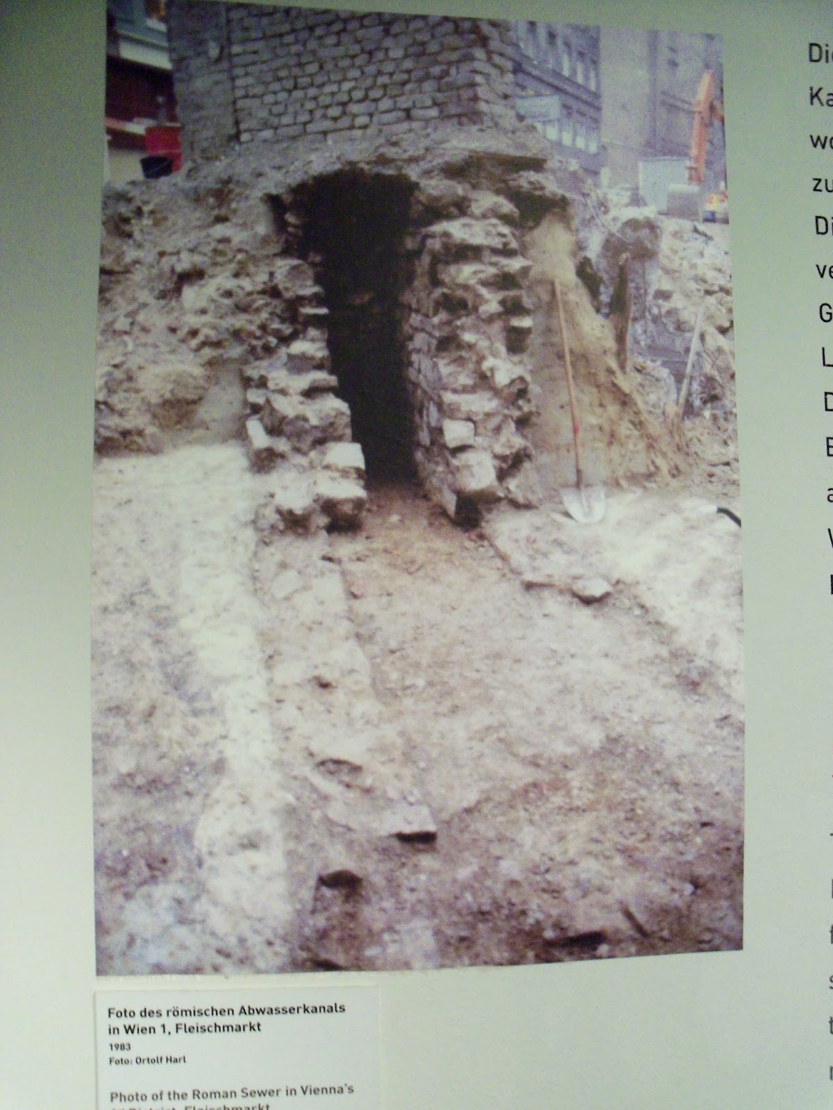
The sewage water of the legionary fortress was collected by a sophisticated canal system, that was provided for from the beginning. The Romans were well aware of the significance of hygiene to avoid diseases. The laid-out canals that were paved with brick plates, ran underneath the main roads. The downward slope of the terrain therefore, was used co cleverly, that the sewage water was drained into the fortress ditches and then further into the Danube. As the canals were over two metres deep, they could be cleared if necessary. Bulky waste was probably mostly deposited on the slope of the Danube. In civil residential quarters, waste was often disposed of using abandoned wells and pits.
In the museum, you can see the old city Vindobona (wall paintings), on the frontier of the Roman Empire (Danube limes),
http://www.wienmuseum.at/en/

- the second part: http://amberroad-mirka.blogspot.com/2013/05/vindobona-once-more.html


The Roman houses at Michaelerplatz under snow.


Building the Museum of Natural History of Vienna.


The Vienna City Hall.


Museumsplatz and snow.


The fountain on Schwarzenbergplatz.


środa, 16 maja 2012

SCIENCE & SCHOLARSHIP IN POLAND PAP – NEWS

2009-03-30, Everything about amber in Poznań's archaeology museum
There were many attractions for the participants of the "Weekend with amber": lectures about amber, a photographic exhibition and a short subject film. The event took place in Poznań's Archaeology Museum on March 28. Anna Majchrzycka, from the Archaeology Museum, informed that the event was inaugurated by a photographic exhibition by Mirosława Stroińska called "In the traces of the amber route". The photos were taken during a foot journey on the Czech-Northern Austrian section of the amber route. The lectures concerned the history of amber. Prof. Janusz Czebreszuk spok of the role of amber in culture, its secrets were uncovered by Dr Joanna Jaworska. Leszek Ziąbka spoke about the world of the Celts and the guardsmen who looked after the trade routes, whereas Angelika Barłóg presented the cosmetic and healthcare values of the "northern gold" - informed Majchrzycka. The visitors also got to see the short subject film "Połów bursztynu" (Amber catching), that was commentated by Eryk Popkiewicz. EKR PAP - Science and Scholarship in Poland, tr. ajb agt/ bsz

poniedziałek, 7 maja 2012

AMBER PORTAL - NEWS

08 August 2007, Amber Route on foot, Written by Anna Sado
The Amber Day marked the beginning of this year’s walking expedition of Miroslawa Stroinska along the Amber Route.
Miroslawa started her expedition last year in Prague and she walked on foot more than 1000 kilometres on the route Praga - Klodzko - Wroclaw - Kalisz - Torun - Kwidzyn - Filino - Mareza - Gdansk. As she did not manage to walk on foot all the stages of the route, she decided to make up for it this year. She started her expedition at Targ Weglowy while celebrating the Amber Day on 28th July and she was to walk on foot the stages Gdansk - Starzyno, Jelonki - Elblag and Jordanow Slaski - Pustkowo Wilczkowskie near Wroclaw. Until 1st August she managed to catch up in Poland – yesterday in the afternoon she was in Zabkowice Slaskie, and today she is heading by bus to Prague, where she is to walk one short stage. There she is also going to meet local newspaper representatives, which last year reported her expedition. If she has enough time, perhaps she will walk a few more kilometres in the direction of Akwilea, although the stage Prague - Akwilea is anticipated for the next year. There she will finish her expedition. And until that time thorough preparations for this exhibition will be in progress, consisting mostly of gathering just enough precise maps – after last year’s expedition they occurred to constitute the biggest problem because they were not precise enough. A problematic issue are also limited funds – sponsors may feel welcome! Moreover Miroslawa is going to get in touch with museum institutions on her route so that they would inform the local residents about her plans, hoping for their more sympathetic response. Miroslawa Stroinska is 50 years old and she is the first woman who took up a challenge of walking along the Amber Route from Sambia to Akwilea. She has been fascinated with this subject for many years and this expedition is a fulfillment of her lifetime dream.

18 August 2010, Polish Woman on the Amber Route, Written by Anna Sado


Mirosława Stroińska from Poznań set off on foot along the amber route this morning. It's the fourth such expedition for her, and the amber route is the last stage of her excursion from Linz to Aquileia. She is the first woman who has taken a challenge to walk through the entire amber route from Sambia to Aquileia, in stages.
This morning, Mirosława Stroińska put her foot on the amber route in Linz, Austria. The aim of her expedition is Aquileia. "I have about 500 km to walk altogether. I am planning to walk about 20-30 km a day, and a little bit less in the mountain areas" – she said while talking to the amber.com.pl portal. She is estimating that the whole route will take her up to 23 days.
This way, a lady in her 50s, who works as a clerk, fulfils her dreams, back from her university days: "I wanted to write my dissertation about the ancient Amber Route, I even had the materials collected, but it didn't work. The fascination with the route didn't fade away and it resulted in the idea of walking the entire route" – explains Ms Stroińska.
This is the last part she has left to walk in the entire Amber Route from Sambia to Aquileia. As a part of the enterprise started in 2006, she has managed to gradually go through the route along one of the ancient routes, which the Romans used for transporting amber from the Baltic seashore to Russia, Poland, the Czech Republic and northern Austria. Mirosława Stroińska is the first woman who decided to walk through the Amber Route.

20 September 2010, Aquileia captured, Written by Anna Sado

“The project of walking the amber route running from the Baltic Sea to Aquileia has nearly been completed. Nearly, because I still have to describe all those interesting, historic places” – sums up Mirosława Stroińska who has finished the last stage of her hiking journey down the amber route.
"This year I really was carrying Baltic amber from Gdańsk to Aquileia, and on some parts of the route I felt like a real Roman merchant" – she said. This year's stage ran from Linz and started at the Danube river which was the natural border between the barbarian countries and the Roman Empire. At the beginning of her route was Wels, the place that used to be a significant, ancient communication junction of the Noricum kingdom. Further on, the route led towards the Steyr river and Teichl stream, running into the river, and then towards the Pyhrn Pass – this section the voyager has evaluated as very difficult. The next part led from the valley of Glan river towards the Carnic Alps and then along the Gail river, Fella and Tagliamento towards Aquileia.
     Mirosława Stroińska had marked up her route earlier on, based on the scientific publication and the map published there – so far she has hiked, in three stages, the route leading from Prague to the Baltic Sea coast, the section from the Czech capital along the Vltava river to Linz in Upper Austria.
     While looking for traces of the ancient amber route the traveller found them most of all in the names of the streets. "In the cities in which the traces of the ancient Roman road stations, post and customs offices were proven there are streets named Römerstraße – Roman street. Even in the Celtic times trade routes used to run there. Nearby Villach is such a route, cut in a rock, where you can see ruts caused by the wagons' wheels" – explained the traveller. The traces of the Romans are also visible just outside Terzo d'Aquileia and then along the way leading to Aquileia. This city, which became the aim of her voyage, Mirosława Stroińska has described as an archaeological heritage park. Other evidence for the existence of a trade route, used to transport among others amber, are the remains of Roman buildings, such as the walls in the centre of Wels and the remains of Virunum city, which after the creation of the Noricum province became its capital, nearby present day Zollfeld.

28 October 2011, A Polish Lady on The Amber Route - an interview with Mirosława Stroińska, Written by Anna Sado


Mirosława Stroińska, from Poznań, has set off yet again for an expedition on foot, down the Amber Route - this year's edition of the project promoted the Polish presidency of the European Union.
     Where did the idea to celebrate Polish presidency of the European Union with an expedition down the Amber Route on foot come from?
I decided that the intentional character of the enterprise is very well suited to the promotional activities of Polish presidency in the Council of the European Union. The Amber Route has connected the societies living hundreds of miles apart. And a trek down such a route gives many opportunities to promote and strengthen the positive image of Poland.
     What did the route of the hike look like?
Initially, as a part of the project I had planned a route along the former limes route (the Roman frontier) on the Danube. It was meant to be a distance of 200 kilometres, starting in Vienna, through Sankt Pölten and Enns to Linz. As we know, at the time of the Amber Route there were main trade centres and customs stations controlling the trade with the nations living over the Danube. The route also included Magdalensberg, and a fragment in Palmanova. Though, due to the holiday I had to cut the expedition short.
     How was this expedition different from the others?
This time, because of the prestige of the project under the patronage of the presidency, my backpack was a bit heavier, as I took my laptop, so as I could send photos and information regularly. The character of the expedition was entirely different: it was not daredevil, I was trying to organise it in a way that would enable me to go sightseeing and document it with photos. It was very important to me that the route would embrace the most representative places and was uncomplicated to such an extent that it would be possible to encourage people to become familiar with the idea of my project. During my stay at the hotel, which I booked in advance, and which obviously had Internet access, having taken a short break to relax I would start writing. The exhibition was shorter because of the restrictions concerning my holiday.
     What was the role of amber in it?
As usual, it was a dominant part, both artistic and usable. While marching in Vienna from one railway station to another, in one of the streets I talked to a woman who was amazed with my amber which I received from amber makers from Gdańsk. And in Magdalensberg, the same as it used to be the case on the Amber Route - trade happened every day and I used amber in the same way: I thanked for water and sweets with a handful of amber. However, this time I wanted amber to have symbolic character, and to relate to the "Polish nature" of the expedition.
     You have been travelling down the Amber Route for a few years - what parts have you got left?
Obviously, everything that I have not realised yet, that is the route along the Danube river, from Vienna towards Linz.

niedziela, 6 maja 2012

POLISH JEWELLERY - NEWS

The Amber Route on foot, Joanna Kulpińska, 2007-09-25 Mirosława Stroińska is continuing her hike along the route based on a scientific publication. Last year, as the first woman from Poland, and also Europe, she covered on foot the 1,020-km section of the historical Amber Route from Prague, Czech Republic, to the Baltic Coast. The principle behind the venture is for it to be a walking expedition only. (...)

The Sunny Workshops: Amber Day 2007, Joanna Kulpińska, 2007-09-25
The amber cockerel ruled over the Gdańsk Coal Market [Targ Węglowy] on July 28. The visitors gathered there took part in the Sunny Workshops of Amber Day. All this in honour of St Dominic’s Fair. It all began with the Amber Cockerel of St Dominic’s Fair.
The event, under the auspices of Mayor of Gdańsk Paweł Adamowicz, was staged by a team of amber jewellers: Aleksander Gliwiński, Mariusz Gliwiński, Anna Nowińska, Dorota Kos and Janusz Wosik. They were supported by Dr Elżbieta Sontag, Ewa Rachoń and Alicja Wiśniewska. The event was watched over by Mariusz Drapikowski. Before the participants began their work on the Cockerel, Mirosława Stroińska had her send-off ceremony for the next stage of the Amber Route.
Afterwards all those gathered in the Coal Market, including Ewa Rachoń, Paulina Binek, Robert Pytlos, Dorota Kos, Mariusz Drapikowski, glued amber pieces onto the body of a cockerel designed by Marzena Niećko. The participants used 10 kg of amber. Despite the efforts of all those involved, the amber bird was not completed. We are continuing this work now, during Ambermart 2007. But the Amber Cockerel was not the only attraction of this year’s Amber Day. Considerable interest was raised by the open workshops and a competition for a jewellery design with a sun image: The Little Amber Sun. Artist Gertruda Wilczopolska was in command here. Lidia Morawska, who made the best sun, was the winner. She received a small amber cockerel for a prize, presented to her by Mariusz Drapikowski. For every woman, and not only, there was a chance to leave the Coal Market with amber jewellery they made themselves. The “Jewellery workshop: amber and ...” had renowned artists help the participants design and make jewels with the Gold of the Baltic. Amber is also associated with fashion. Aleksander Gliwiński presented the latest trends in amber design. Together with Agnieszka Gruszka he created the “Can you imagine?” show, which premièred at the Amberif 2007 Amber and Fashion Gala. Sharp, expressive cuts, purple, brown and green, wool, organza, tulle. All this in the company of the most beautiful Polish export commodity: amber. During the entire day, the “Baltic Amber Inclusions” exhibition of the collection of the Museum of Amber Inclusions organised by Dr Elżbieta Sontag was on display.
As each year, there were historical features as well: archaic techniques of amber working presented by Eryk Popkiewicz and coin minting in the mediaeval way by Narcyz Kalski.Aleksander Gliwiński and Agnieszka Gruszka As we can see, the organisers: the International Amber Association and the Gdańsk International Fair Co., saw to it that no one got bored this year either in the Coal Market of Gdańsk.
Joanna Filipowicz, photo: Polish Jewellery Studio