niedziela, 3 lipca 2022

From Aquileia, for the amber - called "the gold of the north"

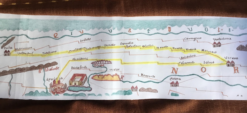
The roads of the Roman territory beginning at Aquileia, as well as their extensions i.e. routes from the middle part of Danube to Baltic coast, along which the amber and other goods were conveyed.
Freehand drawing and the text on the blog, based on the scientific publication: The main Amber Route at the time of the Roman Empire by Jerzy Wielowiejski

The roads joining the North-Eastern Italia (Italy) with the Upper and Middle Danube:

Aquileia - Santicum - Virunum - mountain Pass Pyhrn - Lentia - Lauriacum (the main road). This road built by Celts, and next rebuilt by Romans had, originally, mainly the commercial character. On the other hand, since the end of the 2nd century, in the transport with Lauriacum, the military and administrative needs prevailed.


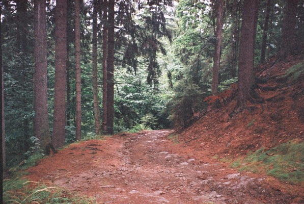
The ancient road in the Austrian Alps.


Aquileia - Carnuntum (the amber road) through Emona, Celeia, Poetovio, Salla, Savaria and Scarbantia. Besides, there was the connection with Savaria through Arrabona to Brigetio, whereas, from Scarbantia there went two branches to Vindobona. In pre-Roman times, this route was of a local character passing round major natural obstacles. It served, first of all, to all needs of particular tribal connections. After conquering Pannonia and Noricum, the Romans quickly adjusted this road to long-distance needs and already in the time of August, straightened the stretch Aquileia - Emona having built a shorter, though steeper route through the mountain pass Piro. A remarkable drainage works were carried out, a lot of bridges were built, many road surfaces were improved.

Ad Pirum
 
The routes joining the Upper and Middle Danube with Baltic, that is transport routes northwards from limes:

Lentia - Lauriacum - Vistula mouth (the amber route), the route passed through (...) the Vyšebrod Pass towards Budziejovice Valley and then along Veltava (Vltava) to Czech Valley. From there the route went through three big concentrations of Roman imports findings over upper Laba (Elbe) across the Polish Gate near Kudowa to Kłodzko Valley and then northwords reaching Odra in Wroclaw (Wrocław) region. The evidence for the existence of amber trade was given by three big amber stores in Wroclaw - Partynice settlement from I century B.C. Further the tradesmen presumably went towards north-east and as far as Prosna river in Kalisz region.

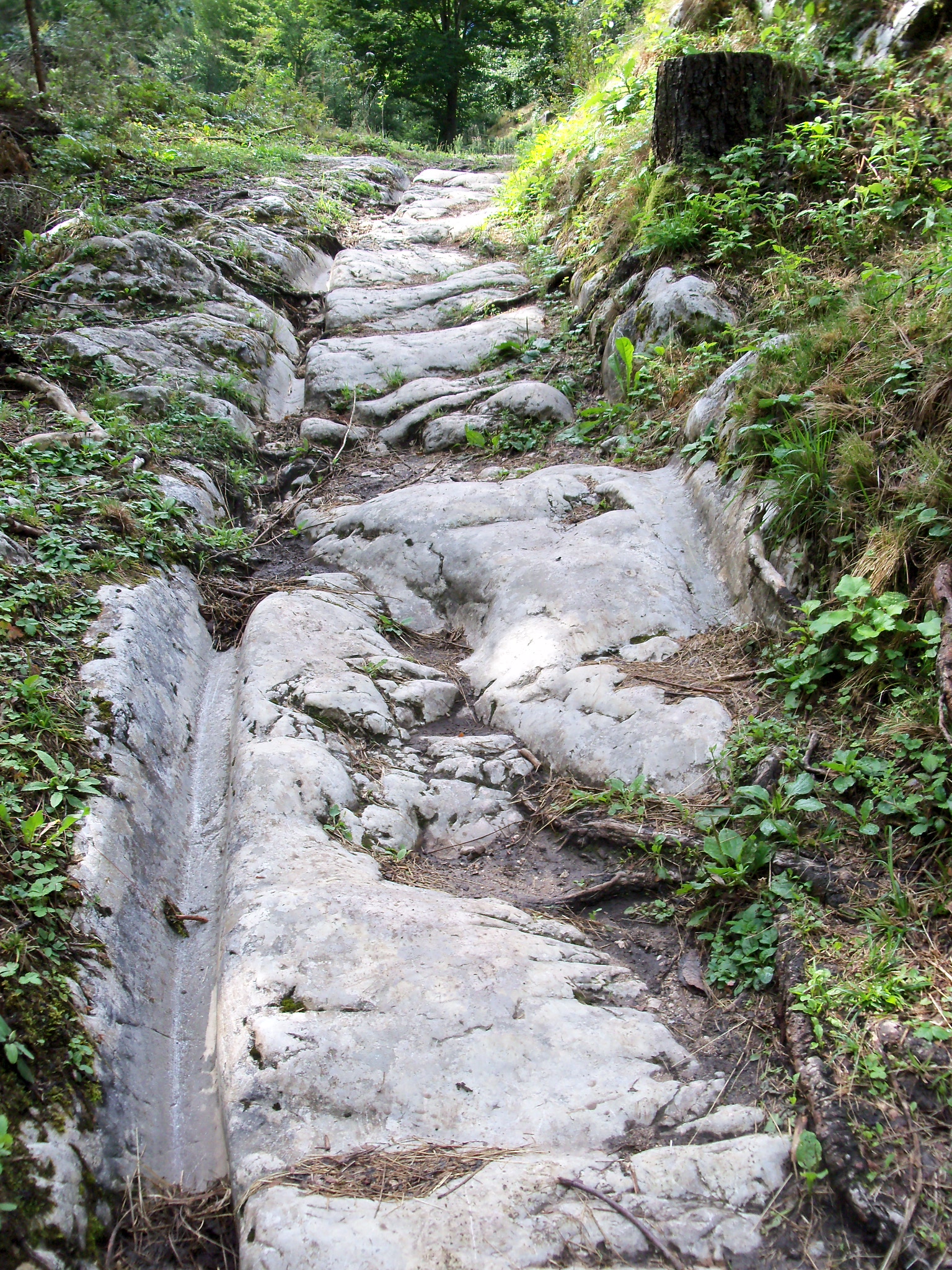
The contemporary amber route in Czech Republic.

(...) It seems probable that Celts during the last century B.C. followed such waterways as Prosna - Warta - Struga - Gąsawka - Lake Pakoskie - Noteć, and then went to the low Vistula. Apart from this west waterway, there was used the east land route through central Kujawy, which passed the Vistula near Otłoczyn. From there, the travellers turned towards north-west and through the Chełmża region reached the Vistula crossing it between Chełmno and Świecie. Next river crossings were in the regions Grudziądz-Rządz-Osiek, Opalenie-Kwidzyn and Gniew at the mouth of Wierzyca river. (...) The tradesmen reached Gdańsk Bay both following the Vistula stream (in Kaszuby coastal area) and its branch Nogat.

 
Walichnowska Valley

Carnuntum - Baltic Coast (the main amber route), first the route went through Zohor or Stupava up Morava river acros the Quadi territory. Next it turned north-eastwards through Moravian Gates in the direction of a big concentration of settlement of Przeworsk culture in Głubczyce upland with the centre near Nowa Cerekiew in Opole province.


 The farther route northwards is difficult to be reconstructed because of the thick forest dividing the upper Odra from upper Prosna. It could have been the inter-tribal land which was probably by-passed by tradesmen from the west and along Prosna to Kalisz region, where several routes crossed.


 The main amber route presumably went in the north-east reaching Rumin near Konin where the crossing through Warta was convenient. After crossing it, the route went first westwards, through Kleczew and Paniewo in Konin province, and then northwards along the west side of Gopło lake reached a multi-functional settlement at Krusza Zamkowa in Bydgoszcz province near the crossing across Noteć. Then the route went north-eastwards and came to the crossing across the Vistula near Otłoczyn. The further route north-westwards to Chełmno and next to the Baltic along the Vistula was essentially similar to the Lentia - Lauriacum - Vistula mouth route, however the east side of the river was preferably used. From the Wielbark - Gościszewo region over Nogat, there was the connection through the settlement in Elbląg upland and aquane of Zalew Wiślany with the biggest amber layers on the Samla-land Peninsula (Sambian Peninsula).

 The ferry, near Rumin on the Warta.

The east branches of the amber route coming out from Brigetio-Celemantia (...) reached the upper Odra, and the route from Vindobona to the mouth of Odra.

Roman legionaries, Vindobona

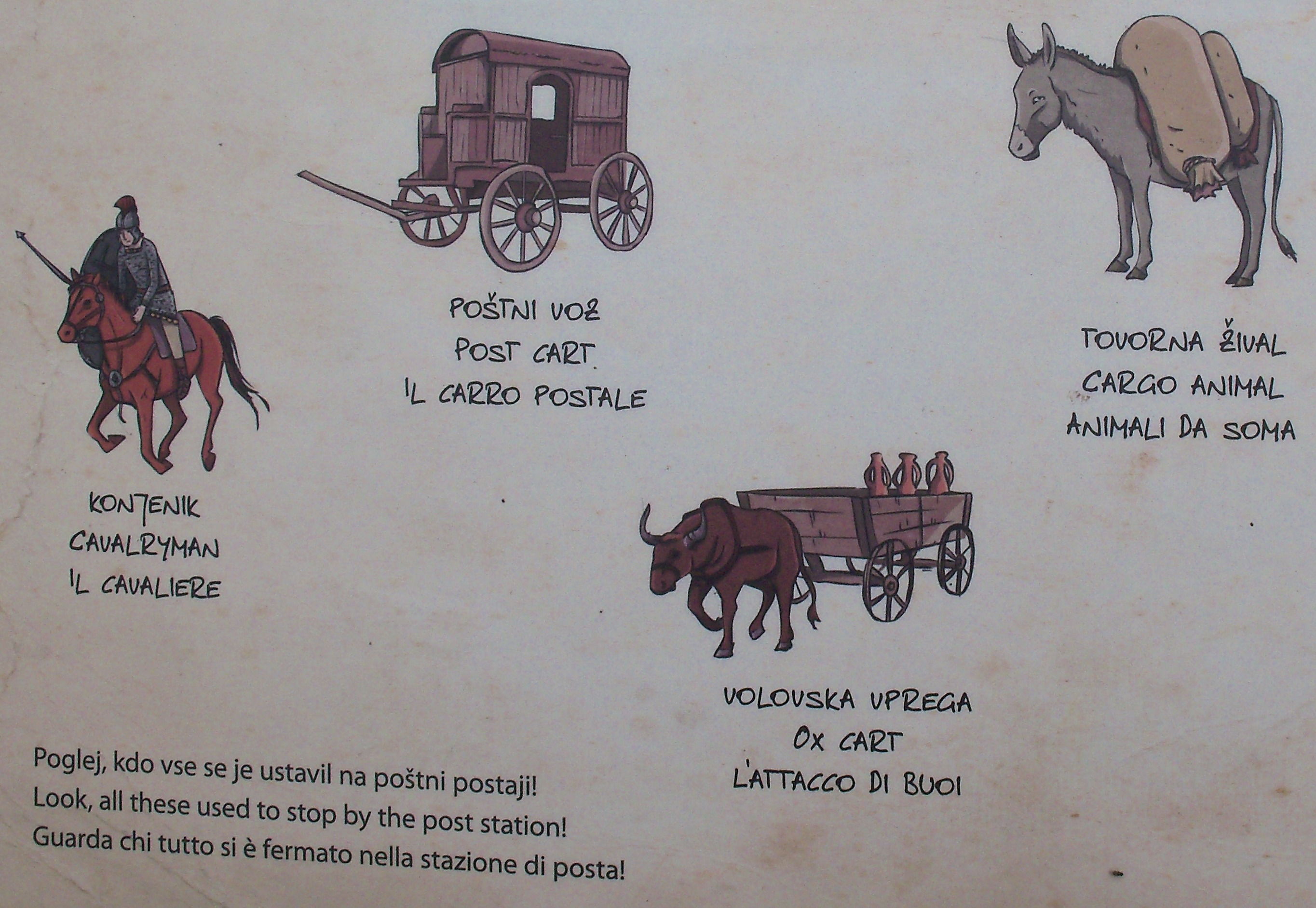
The tradesmen, first of all, made use of the land transport. In the Roman roads, carts driven by mules, donkeys or horses were used and northwards from Danube by beasts of burden.

wtorek, 29 maja 2018

Factory (Trading Post) Pruszcz Gdański

An important trade hub at the mouth of the River Vistula and centred around Pruszcz Gdański existed from the 2nd century ad to the mid-5th century ad. It was here that various branches of the Amber Road converged, linking the north with the Roman Empire. The principal route of the Amber Road crossed the Danubian provinces reaching the southern shores of the Baltic. There was also a maritime route at this time which linked Pomerania with the western provinces of the empire, as well as a south-eastern route running from the Baltic to the northern shores of the Black Sea.
The Factory (Trading Post) was the economic and cultural hub of a settlement, constituting a meeting point on the trade route. Sites of this type were encircled by a palisade safeguarding the inhabitants, merchants and valuable trade goods. Trade settlements served a vide variety of functions in antiquity. They were places were trade transactions and social meetings took place and where knowledge and experience could be shared with those arriving from other parts of Europe.

The wealth of archaeological discoveries made since then and their contribution to our knowledge of the history of the Pomerania region inspired the creation of the reconstructed trading settlement known as the Pruszcz Gdański Trading Post (Faktoria w Pruszczu Gdańskim). Today, the Roman period trade settlement is a modern exhibition and education centre. Archaeologicał artefacts recovered from the urban territories of present-day Pruszcz Gdański are displayed in the Chieftain's Hut. The items in question come from the collections of the Archaeological Museum and the Amber Museum in Gdańsk. The exhibition is entitled The Magic of the Amber Road - Treasures of Pruszcz Gdański. Visitors can marvel at the skill of ancient amber-workers, as reflected in masterfully crafted jewellery and dress accessories. The exhibition also showcases items which were brought to Pruszcz from the far-flung provinces of the Roman Empire.

The Hut - an extremely interesting object.

It’s a place, where you’ll travel back in time almost 2000 years.

The Amber Craftsman's Hut is a reconstruction of his workshop. It  presents tools he used, and items that came out his hand. During archaeological excavations conducted in the area of Pruszcz Gdański, there were found a lot of beautiful amber jewellery, reflecting the extraordinary capacity of local amber craftsmen. Just at the entrance you can see his tools: turning lathe, knives, files, flint blades, stone board for smoothing, gimlet drilling, felt and leather of a deer for the final smoothing and others.
 
The Amber Craftsman's Hut

The Amber Craftsman's Hut

Inside, the building is divided into two rooms with the wall made of plaits.

Behind the wicker wall there is a reconstruction of a vertical loom.

The wicker wall. Moreover, there is a fireplace and dome stove, made of clay and branches, dug in the ground.

The Amber Craftsman's Hut and on the left there is a trolley.

The Blacksmith's Hut is a faithful reconstruction of a house from the Roman influence era. All the items of material, wood and wicker were made in the traditional techniques. Before entering the hut you can see the blacksmith’s workshop: a furnace with bellows and wooden barrels with water, used for hardening manufactured items. On a wooden tree stump there are basic tools of there the manufacturer: anvils, tongs, hammers, files, perforating punches, and others.

The Hut itself was made of oak wood and conifers. The substrate is wooden, made of planks of logs. In the hut there are typical household utilities: in the corner you can see a rectangular fireplace, a bed covered with fur and hand-woven, woolen textiles, table and seats, a trunk, performing the functions of a bench for sitting and locker for items as well.

The Blacksmith's Hut, it is worth noticing that - generally - ancient tools used by blacksmiths have survived in its original form until day.

The gate tower and the palisade.

The Amber-Worker's and Blacksmith's Huts are houses incorporating workshops which have been recreated based on archaeological evidence.

The farm

Outer material of a roof

Assisted by re-enactors, visitors to the Trading Post can try their hand at a number of ancient skills, including archery, pottery, amber-working and wood tar production, as well as sample smoked fish made in a prehistoric smokehouse.


Department of Historical Reconstruction
Center of Culture and Sport
Pruszcz Gdański

sobota, 1 marca 2014

Leonding City Museum

The Limes road linked the individual military installations and other ancillary features. Quite often along a natural boundary, the Limes road runs well behind the course of the river, dictated by the terrain. Watch-towers and fortlets and sometimes also forts, are connected to the supra-regional Limes road with smaller roads. Between the outposts it was possible to communicate by signalling with fire. "Some of these towers, especially those in exposed places, were most probably used as a signalling posts. Signalling with fire must have been common at that time and therefore it may be of interest to mention the functioning of signalling with fire as described by Sextus Iulius Africanus in his encyclopaedic work “Kestoi” in ca. 230 AD . He was the only author to describe this system; however, since he was a Greek-speaking author he wrote about how to signal in the Greek alphabet. He described the technique as follows: “Romans use the following technique, which seems to me extraordinary. If they want to signal with fire they do as follows. They choose the suitable places for signalling. They have three fires - on the right, on the left and in the middle, meaning alpha to theta on the left, from iota to pi in the middle, and rho to omega on the right. If signalling a letter alpha they lift the fire on the left once, for the letter beta twice and for the letter gamma three times, and so on. The receivers of the signal can easily decode such signals and transmit them to the next outpost”." Peter Kos (Ljubljana), Claustra Alpium Iuliarum - Protecting Late Roman Italy

The watchtower at Hirschleitengraben on Kürnberg (possible, that it looked like this) is situated in the woods on higher ground overlooking the Danube to the east of Wilhering. The first tower (6 x 6 m) was build at the end of the second century AD after the Marcomannic Wars to secure this Limes section with additional fortifications. The later larger tower (9.2 x 9.3 m) surrounded by a ditch belongs to the late Roman period.

On the streets most people moved on foot, on riding horses, or by traveling coach although this was reserved for a better-off clientele.
To the east of Wilhering the Danube valley open up into the Linz basin. Here was a pre-Roman Danubecrossing of the Norican highway, which runs from Carinthia and the Magdalensberg area into the center of Bohemia. The location of Linz appears to have been used from Celtic times onwards.

The museum Stadtmuseum Leonding is housed in one of the towers Maximilian´s former defenses.

text from:
Frontiers of the Roman Empire (...)
www.limes-oesterreich.at

niedziela, 15 września 2013

Enns

The road Aquileia - Santicum - Virunum - mountain Pass Pyhrn - Lentia - Lauriacum was connected the north-eastern Italy with the upper and middle Danube. This road built by Celts, and next rebuilt by Romans had, originally, mainly the commercial character. On the other hand, since the end of the 2nd century, in the transport with Lauriacum, the military and administrative needs prevailed.
There was a civilian settlement at the confluence of the Enns river from the first century AD onwards. However, the first military installation in the area, which secured the Upper and Middle Danube against the Marcomanni and their allies, was built east of the river Enns directly at the river bank of the Danube close to Albing, with the legio II Italica and other auxiliary units, and maybe also parts of the fleet in place. The fortress close to the wetland area was given up shortly afterwards. After the Marcomannic Wars the legion transferred to Enns, where near the civilian settlement, builded the new legionary base Lauriacum (the ancient name for Enns). Equipped with extensive military and civilian infrastructure, Lauriacum becomes the seat of the governor of Noricum, and the important administrative center.

Outline of a building of the first military camp in Albing (Google Maps). The frontier line in Austria is part of the whole defence system along the river Danube from Bavaria to the Danube delta beside the Black Sea.

The walls of a Roman house (II - III century) in Enns and the Basilica of St. Lawrence.

Possible that a similar specimens grew in ancient Lauriacum, where in the civilian settlement craftsmen and merchants lived.
At the same time as the legionary camp was being built, to the west of it soldiers also were building a large civil settlement, which in 212 received the rights of a city. It was the typical Roman "civilian city" with the insulae. Those town-houses were finished with great comfort. They featured inner courtyards with gardens, heating systems, and the rooms were partly decorated with wall paintings and mosaic floors.        
In the third century Lauriacum developed into the commercial center at the Danubian Limes. A trading firm from Aquileia, which exported salt, iron and precious metals from Noricum, settled here.

Museum Lauriacum - Museum der Stadt Enns

Terra sigillata vessels, the 2nd and 3rd century.

Model of floor and wall heating
This heating system was known as the hypocaust. The paved floor was raised on pillars, and hollow bricks were installed inside the walls. Hot air from the furnace circulated under the floor and around the walls and heated the entire room.

The Roman decorative roofing tiles:

chimney pot,

ridge tile with the mask.

text from:
Frontiers of the Roman Empire (...)
www.limes-oesterreich.at

czwartek, 12 września 2013

Pöchlarn


The small castle in Klein-Pöchlarn :)

The exhibition in the Stadtmuseum Arelape-Bechelaren-Pöchlarn

At the beginning of the 1st century, the Austrian section of the Danube became the northern border of the Roman Empire. In the same century, the Romans established a camp named Arelape. First built in wood-earth construction. Later, the legionary barracks were fortified by building the stone defensive wall. The fort was rebuilt several times. In late antiquity, the older fortifications were strengthened by the construction the second camp wall and new towers: U-shaped and fan-shaped.

Three-dimensional reconstruction of the walls of the fort Arelape. This Roman camp was about 155 x 155 m, which corresponds to the area of 2.4 ha.

Model of the Roman warship (liburna), the fast, maneuverable galley with the sail and ram on the bow. In late antiquity, Pöchlarn was the seat of a commander of the Danube-flotilla.

The civilian settlement near the fort.

The Arelape fort, was one of the auxiliary camps on the Roman Danubian limes in the province of Noricum. The cohors I Flavia Brittonum and cavalry formation (equites Dalmatae) were stationed here.

The museum is located in this massive tower.

River transport on the Danube, just like in the Roman times.